

The Property Profile tool is a convenient and easy way to access information about any property in Austin. Whether you are looking at a new home, planning a renovation, or just curious about the history or future of your neighborhood, this tool can help you find what you need.
The Property Profile tool is designed to provide accurate and up-to-date information from the City's official records. Please note that some data may not reflect recent changes or updates. If you have questions or concerns about the information provided by this tool, we recommend you contact the Neighborhood Assistance Center. The NAC offers training with online tools to better understand development within the City of Austin while maintaining the Community Registry, a database of self-registered neighborhood associations and other community organizations.
Launch Property Profile
Getting to Know the Layout
You can search for properties by address, parcel number, or case number. You can also browse the map and click on any property to see its details on its zoning, land use, assessed value, tax information, or building permit history like date, type, status, and description.
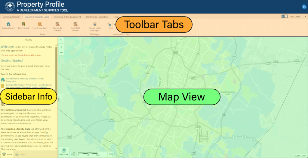
Toolbar Tabs - Contains tools for viewing, searching, drawing, printing, and reporting data from within the Property Profile Tool.
Sidebar Info - This left section displays your property search and property information. Property information is listed and linked to view more detailed information and reports.
Map View - This is the main map section of the tool. Users can navigate the map using the mouse by dragging to pan and scrolling to zoom.
- Getting Around
-
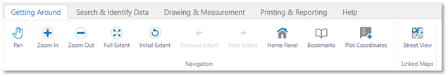
- Pan Tool – Allows you to grab and move the map in view.
- Zoom In – Increases zoom on map.
- Zoom Out – Decreases zoom on map.
- Full Extent – Resets map view to entire selected region.
- Initial Extent – Resets map view to previous view scale.
- Previous Extent – Sets map view to last known view scale.
- Next Extent – Sets map view to next known view scale.
- Home Panel – Opens the Home info panel.
- Bookmarks – Reveals saved bookmarks over map view.
- Plot Coordinates – Click on the map to add pinned coordinates.
- Street View – Opens the street view window for the selected location.
- Search & Identify Data
-
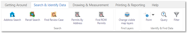
- Address Search – Search by property address.
- Parcel Search – Search by Appraisal District Geographic ID or Property ID.
- Find Review Case – Search by review case number or name.
- Permits by Address – List permits by address.
- Find ROW Permits – Find ‘Right of Way’ permits.
- Change visible map layers – Add/remove data layers to map view.
- Point – Add a point to the map.
- Drawing & Measurement
-
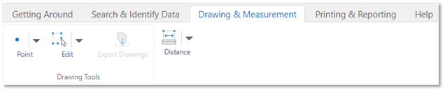
- Point – Add a point to the map.
- Edit – Edit a point on the map.
- Export Drawings – Export a map with points.
- Distance – Measure the distance between points.
- Printing & Reporting
-
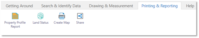
- Property Profile Report – View/download a property profile report.
- Land Status – View/download a land status report.
- Create Map – Prepare a map view for printing or PDF.
- Share – Share your map view with social networks.